WE LIVE in an age of exploration unlike any other.
Forget Columbus, Magellan, and Vasco-da-Gama; while they sailed across the globe in search of new continents, the rest of Europe stayed home. Now, anyone with an Internet connection can explore the wonders of the natural world, from the Grand Canyon to the Great Barrier Reef.

A Google employee, armed with a specialized Street View 360 degree camera, prepares to document the Grand Canyon. Photo Credit: Google.
Thanks to Google Street View, the innovative immersive media technology that allows users to interact with a 360-degree panorama of a given location, much of the previously inaccessible world is right at our fingertips. If you cared to, you could explore over 7 million miles of roads in at least 65 countries, panning and zooming to examine features in an interactive middle ground between photography and reality.
And the tech giant hasn’t stopped there.
Google has begun uploading Street View Treks, their term for new imagery of hiking trails, national parks, remote islands, and coral reefs. You can take a virtual cruise on the Amazon River, explore a photosphere of a penguin colony in Antarctica, or even “walk” along the tropical beaches of the Pitcairn Islands in the middle of the Pacific Ocean.
But what does virtual sight seeing have to do with conservation?
One of the widely accepted benefits of travelling is that it broadens horizons and exposes people to new ideas, and for visitors to national parks and marine protected areas, conservation is often one of those ideas. By experiencing the benefits of conservation firsthand, people are more likely to place a higher value on protecting the ecosystems they visit.
Of course, it’s hard to compare the benefits of virtual sightseeing to those of actual travel. But for some destinations, where physical travel is prohibitively difficult or expensive, it’s an acceptable substitute.
For example, consider the Great Barrier Reef. Although it’s the classic bucket-list destination, many people will never make the arduous journey to visit. But now, anyone can explore the reef with the click of a button.
Through a partnership with the Catlin Seaview Survey, Google has worked to bring the reef to life, syncing 100,000 underwater pictures of the Great Barrier Reef to Google Maps. The pictures are stitched together to create interactive photospheres feature towering corals and schools of brightly colored fish, and allow visitors to toggle, zoom, and explore the reef much like a SCUBA diver would. More importantly, the pictures allow people to witness the damage caused by coral bleaching and crown of thorns starfish firsthand, emphasizing the need for coral reef conservation in the process.
Curious Google Maps users aren’t the only ones exploring the virtual reef. Scientists are making use of the treasure trove of data to analyze trends in coral bleaching, reef growth, and marine animal migrations. As Google divers return to the reef in the years to come, they will generate a series of reef images that scientists can use to study the effects of cyclones and ocean acidification on corals in the coming decades.
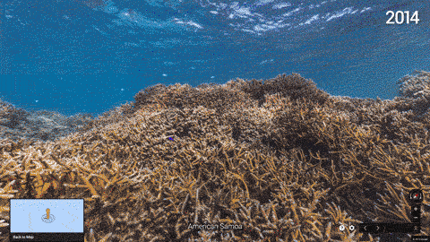
Street View imagery depicting a coral reef in American Samoa before and after a bleaching event. The delicate symbiosis that exists between corals and their resident algae, known as zooxanthellae, breaks down when ocean temperatures rise too high, causing the corals to turn ghostly white. Climate change and the current El Niño are responsible for the extreme coral bleaching seen this year. Photo credit: Google.
Google Trek images of rainforests and reefs provide scientists with valuable data, but the 7 million miles of street level images hold value for research too. Conservationists can use roadside imagery to assess habitat quality and to species diversity. While roadside imagery may be unsuitable for researching some ecosystems due to edge effects, it can save researchers time and money when used correctly.
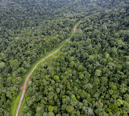
The edge effect is a biological phenomenon where species avoid roads and other habitat edges. For some ecosystems, such as forests, that makes Street View less suitable for research. Photo credit: Mongabay.com.
Cliff faces, which support a surprising amount of biodiversity from plants to nesting birds, are one such ecosystem where Street View imagery can enhance research. Unlike forests, which are routinely studied using satellite data, the biodiversity of vertical cliff ecosystems is difficult to analyze from space. For researchers studying vultures in Spain, Google Street View was the next best option for remotely assessing the habitat quality of cliff faces where vultures nest. Analyzing the images didn’t replace actual fieldwork; instead the use of Street View helped researchers narrow down potential study sites and perform rudimentary habitat assessment, saving them time and money.
Scientists increasingly rely on satellites or cameras to detect measures of habitat quality and land use change. Called remote sensing, this important emerging field of ecology allows researchers to save resources while revealing biological patterns invisible to the naked eye.
Although less glamorous then satellite imagery, Google Street View can be considered a form of remote sensing. For now, research using Street View is limited to the analysis of photographs, but that will change in the near future. Alcima, a startup specializing in environmental sensors, has partnered with Google to retrofit Google’s Street View cars with air quality sensors. These cars will effectively map air pollution as they drive by tracking changes in the concentration of ozone and nitrous oxide. The project is still in production, but public data on street level air quality will become a powerful tool for activists to track localized pollution and spurn changes in polluted areas in the future.
What YOU can do
From coral reefs to cliffs to congested air, scientists are using Google Street View to monitor our environment and detect global changes. With these images available for the entire online community to view, you can contribute to a variety of global conservation initiatives in just a few clicks. Here’s how.
- Explore – Choose an exotic natural ecosystem that you’ve always wanted to explore but never gotten the chance to see. Whether it’s Antarctica, the Amazon Rainforest, or the Great Barrier Reef, you can develop a closer connection and a more realistic mental picture of your ecosystem of choice by exploring it on Google Street View.
- Learn – Learn about the threats facing your ecosystem of choice, and look for signs of those threats on Google Street View. Check out environmental monitoring databases such as NOAA’s Coral Reef Watch, which maps coral bleaching events in real time, to get a better idea of the severity of these threats.
- Participate – Bridge the gap between exploration and discovery by participating in citizen science research projects. Researchers that rely on Google Street View to collect data have lots of pictures to sift through, and online initiatives like Darwin for a Day, a species identification project in the Galapagos, help to expedite research and allow you to get involved with cutting edge science.
So get online and get involved. By following the steps above, you can turn Google Street View into a tool of exploration unlike any other.
LEARN MORE
- Explore over 100 of the world’s best dive sites using Google Maps
- An incredible compilation of Google Street View Treks
- Google will start mapping pollution the same way they map streets
- Use Google Street View imagery to help identify species on the Galapagos with citizen science project “Darwin for a Day”


[…] by negative environmental news, and 2015 was no exception. El Niño climate craziness, coral bleaching, Indonesian wildfires, and the death of Cecil the lion filled the front page. If you didn’t dig […]
LikeLike
[…] quick glance at Google Street View shows a shoreline covered with Styrofoam containers, fishing buoys, nets, and plastic detritus of […]
LikeLike
[…] so that researchers can analyze their behavior patterns. Other commonly used online tools, such as Google Street View, have proven to be useful citizen science […]
LikeLike
There needs to be a Google world museum. The things you guys pursue reveals a humanitarian thread at that organization. I hope you’ll thrive fiscally, so your vision of a better world emerges through your many projects.
LikeLike